Showing posts with label infrastructure. Show all posts

Tuesday, February 12, 2013

Earth Satellite Station

SATELLITE COMMUNICATIONS EARTH STATION
The commissioning of the Satellite Communications Earth Station, Kuantan, Pahang, heralds Malaysia's entry into the Space Age. Built on a 60 acre site on a small plateau overlooking the scenic beaches of the East Coast of West Malaysia, the Station will link Malaysia via the Indian Ocean Intelsat III Satellite, initially with India, Indonesia, United Kingdom, East and West Pakistan, Japan and Australia. These links will provide high quality overseas telephone, telegraph and telex circuits which are vital to the development of Malaysia's trade and economy. The Earth Station is also equipped to relay live television programmes between Malaysia and these countries. The total cost of the Earth Station Project, including land and buildings amounts to M$9 million (US$3 million) and the successful principal contractor for the Antenna and Electronic Equipment was Mitsubishi Shoji Kaisha Ltd. of Japan.

The key components of the Station are the 97 foot diameter fully steerable antenna, the supersensitive helium refrigerated low noise receivers and the high-power microwave transmitters. The moving structure of the antenna weighs 300 tons, yet the antenna must aim at the satellite 22,300 miles up in the sky with an accuracy better than one minute of an arc. The big antenna must maintain the accuracy of its reflecting surface to within 1.2 millimeter in order to concentrate the radiated microwave power towards the satellite equivalent to 1000 million watts. The design and construction of the Station indeed stretches modern technology to its limits.

Kuantan is chosen as the site of the Earth Station on account of its complete freedom from interference from existing terrestrial microwave stations. In addition, Kuantan has reasonable amenities for staff and is linked back to Kuala Lumpur by a high quality microwave system. 

Satellite communication is organized on a global basis through the International Telecommunications Satellite Consortium or INTELSAT. This Consortium now has about 71 Member Countries. Malaysia is the 50th Member with a capital share of approximately 0.25%, Malaysia is represented on the governing body, the Interim Communications Satellite Committee (ITSC) through a Joint Representative in partnership with Thailand, Singapore, India, Ceylon, Philippines and New Zealand. The Consortium is responsible for purchasing, launching and maintaining the satellites in the sky. The establishment and operation of the earth stations however, are entirely the responsibility of the countries concerned.

Malaysia's Earth Satellite Station is not a turn-key project. The specifications and the system engineering designs were prepared by Malaysian Telecommunication Engineers who have also supervised the installation, testing and completion of this project. This is indeed an achievement of which Malaysia is justifiably proud.

TECHNICAL DETAILS
Commemorative postage stamps of 15 cents and 30 cents denominations will be issued to mark the commissioning of the Satellite Communications Earth Station at Kuantan, Pahang.

SIZE: Trapeziform for the 15 cents denomination and rectangular for the 30 cents denomination with the following dimensions perforation to perforation in sheets of 100 -

15 cents - Vertical (Right side) - 30 mm, Vertical (Left side) - 15 mm, Horizontal (43 mm)
30 cents - Vertical - 30 mm
(Types A & B) Horizontal - 43 mm

DESIGN:
15 cents - The design depicts a view of the steerable antenna of the Earth Station against the background of the sky

30 cents - The design, which is common to both types, depicts the Satellite "Intelsat III" orbiting in space above the portion of the Earth showing Malaysia.

Type A: The words "Intelsat III", "Malaysia" and the denomination in white. The stars in the background in silver.

Type B: The words "Intelsat III", "Malaysia" and the denomination in gold. The stars in the background in silver.

PRINTING PROCESS: Photogravure

COLOUR: The stamps are in multicolours

PAPER: Unwatermarked paper

PRINTED BY: Messrs. Joh Enschede en Zonen, Holland

PERIOD OF SALE: Until stocks are exhausted

FIRST DAY COVER


Tuesday, October 30, 2012

International Airport

THE INTERNATIONAL AIRPORT
The opening of the Kuala Lumpur International Airport in 1965 by His Majesty the Yang Di-Pertuan Agong completes a further stage in the 2nd 5-Year Development Plan being undertaken by the Government of Malaysia.

The new Airport is connected to Kuala Lumpur 14 miles away by a fast motorway which takes 20 to 30 minutes.

The opening of the new Airport means that all Air Lines will be able to include Kuala Lumpur in their schedules and it is expected that this modern Airport will become a focal point for all traffic between the East and West.

The civil engineering works were designed by the Headquarters staff of the Public Works Department who have accomplished a project of which they can be justly proud. It has been designed to incorporate modern airport development and will cater for all existing types of aircraft which may appear in the foreseeable future.

The site is ideal as there are no large obstructions in the vicinity and the orientation of the runway fits in perfectly with the main prevailing winds from the South-West and North-East. The site preparation involved the removal of a village to a new location, the clearing of 500 acres of rubber trees and the excavation of some 6.5 million cubic yards of soil.

The runway and the parallel taxiway have been constructed by Messrs. Gammon-Hawaiian Dredging-Pomeroy. The pavement comprises a layer of lime stabilized soil on the formation and bitumen bound bases and wearing surface, this type of construction being the first of its kind in this part of the world. The total area of paving is 550,000 sq. yds. A major problem in this country, with its high rainfall, is drainage and 8.5 miles of piped drains and 14.5 miles of open drains had to be provided. All areas outside those paved are turfed and amounts to 2,000,000 sq. yds. The airport complex covers 54 acres and is surrounded by a fence.

Both approaches are provided with centerline and bar lighting together with circling guideline lighting. The runway is equipped with edge and threshold bar lighting and visual slope indicators. The taxiways are equipped with centerline lighting and in certain areas edge lighting. The airport will be equipped with VOR/DME radio equipment together with an instrument landing system. It is also proposed to provide shortly, radar surveillance equipment. The navigational aids provided will enable pilots to descend through cloud to a height at which they can utilize the visual landing aids.

The terminal building and other ancillary buildings located towards the southern end of the runway were designed and the construction supervised by a Malaysian firm of Architects - Messrs. Booty Edwards & Partners. The terminal building together with the control tower form a covered area of approximately 350,000 sq. ft. The roof comprises a series of reinforced concrete hyperbolic paraboloid panels at 48 ft. square, and supported by 36 foot R.C. columns at 48 foot centres. External noise has been minimized by providing a band of air-conditioned rooms with double glazing on the side of the building adjacent to the parking apron. Rubberized flooring has been used extensively.

The ground floor of the terminal building contains offices for the Departments of Civil Aviation and Meteorology, and Airlines together with the main kitchen, electrical and air-conditioning plant. The first floor is a passenger concourse and vehicular traffic is accommodated on a covered roadway which is an integral part of the building. All check-in and ticket counters, arrival and departure halls, reception, interview and V.I.P. rooms, shops and other public facilities are located on this floor. The second floor which is of Mezzanine has two gentry rising spiral ramps sweeping up from the concourse level which serve as the principal means of access. On this floor there is an air-conditioned public observation terrace and an open air dining terrace and dance floor. The 134 ft. high control tower is a separate structure connected to the terminal building by a covered way.

This project is the largest in South East Asia and was completed in a period of 30 months at a total cost of M$52 million.

Technical Details
Special postage stamps of the 15 cents and 30 cents denominations will be issued on the 30th August, 1965 to mark the opening of the International Airport in Kuala Lumpur.

Size: Rectangular with the following dimensions perforation to perforation, in sheets of 100 - Horizontal - 36 mm, Vertical - 25 mm.

Printing Process: Photogravure

Design: The design features the International Airport Terminal Building

Colours:
15 cents - Building - grey, Sky - blue

30 cents - Building - grey, Sky - red

Paper: PTM watermarked white paper

Printed By: Messrs. Harrison and Sons Ltd., London

The stamps will be placed on sale in all the territories of Malaysia for a period of three months from the date of issue or until stocks are exhausted whichever is earlier.

First Day Cover

Wednesday, October 24, 2012

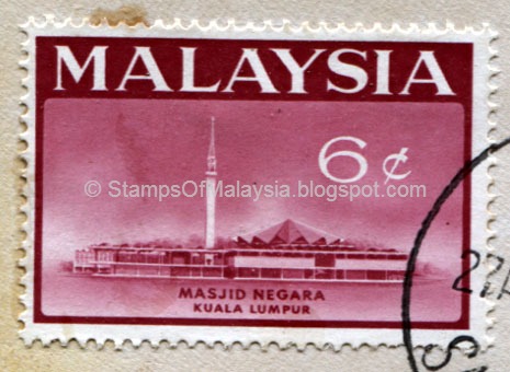
The Opening of the National Mosque

At its meeting on the 30th July, 1957, the then Executive Council agreed in principle that the Federation Government should make a substantial contribution towards the construction of a National Mosque in Kuala Lumpur as a gift form the people of the Federation to the Yang Teramat Mulia Tunku Abdul Rahman Putra, then Chief Minister, in appreciation of his services in leading the country to independence.

At a meeting on the 5th March, 1958 of the Menteris Besar and Chief Ministers of the eleven states comprising the Federation of Malaya, it was agreed in principle to construct a National Mosque in Kuala Lumpur to be named "Masjid Tunku Abdul Rahman Putra". A Central Committee headed by the Deputy Prime Minister was formed to be responsible for the administration of the funds, acquiring the site, construction of the Mosque and determining the policy for the collection of funds, etc. throughout the country. The name has been changed at the request of the Prime Minister, Tunku Abdul Rahman Putra to Masjid Negara (National Mosque).

The National Mosque was designed and supervised by the Architects and Design Research Branches, Federal Public Works Department and has taken just over 3 years to complete at a cost of $10,000,000.

Public donations have been received from people of all races and religions in the country. The mosque in fact symbolizes the goodwill and brotherhood of the people.

It stands diagonally opposite the Central Railway Station of Kuala Lumpur, the capital of Malaysia in a laid out garden of approximately 13.5 acres. It forms an impressive termination point to a long view from one end of the multi-level fly-over which spans the Klang River.

The building itself occupies an area of almost 5 acres and consists of the Grand Prayer Hall providing a floor area of 22,500 sq. ft., the Dewan, the Mausoleum, the Library, Offices, the open courtyard and the Minaret.

The Grand Hall is surrounded by deep verandahs which are screened off by gleaming white terrazzo grille work of traditional Islamic designs similar to those in the mosques at Agra and Patephur Sikri in India. It is covered by a high pleated shell concrete dome taking the shape and form of an open umbrella and is supported by 16 columns each of 3'0" diameter. The span of the dome is approximately 145'0" from centre to centre of columns, its apex rising 84'0" above the floor level.

The Grand Hall and the verandas provide a praying space of 80,000 sq. ft. which can accommodate 8,000 people. The floor of the Grand Hall will be covered with fixed carpet whereas the rest will be finished in precast terrazzo slabs.

The Dewan is located on the south side of the Mosque and is an all purpose hall which can seat 500 persons. It has an interesting shell concrete roof in the form of pleated and connoid vaults and is connected to the Main building by a short but wide covered way which during Ramadzan and other religious occasions will serve as a feasting area and also a dias for the annual Quran Reading Competition.

The Mausoleum, situated at the rear of the Mosque, stands in a circular reflecting pool and is connected to the main building by a covered footbridge. It is circular in design and is also covered by a pleated shell concrete dome similar in shape to that of the Grand Hall but having only seven folds one of which covers a reserved area for a National hero's tomb.

The air-conditioned Library and offices are situated to the rear of the main building.

The open courtyard is an important element in the tradition of mosque planning and is placed in front of the Grand Hall. Courtyards in mosques in the Middle East are open to the sky and are invariably furnished with a cluster of fountains in a pavilion or an open pool where ablutions can be performed. The courtyard in the National Mosque is partly covered by 48 independent concrete parasols to provide shade and architectural contrast, the fountains for ablution being located at the floor beneath.

The Minaret is square on plan 12'6" & 12'6" rising from the centre of the long and narrow reflecting pool by the side of the Grand Hall. It has one viewing balcony 138' above the main floor which is accessible by a lift and a spiral staircase. The top of the minaret is decorated with a concrete spire which takes the form of a closed umbrella and soars 90' above the balcony. This completes the theme of the design of the National Mosque, Masjid Negara in Malay, which is based on an open umbrella for the dome over the Grand Hall and a closed umbrella for the spire.

The main floor level of the building is 32' above the Road and is accessible on three sides by wide staircases. The main entrance is on the east side and will primarily be used by those who come on foot whereas those who visit by cars will enter by the south entrances adjacent to which car parks are provided, the north entrance being used by those visiting the Mosque via Young Road.

Ladies have a separate entrance directly connected to the Ladies Ablution Hall and they will offer their prayers in the Gallery at the north end of the building. This Gallery also provides booths for Television and Radio services and sitting accommodation for visitors wishing to witness proceedings held in the National Mosque.

Technical details
Special postage stamps of the 6 cents denominations will be issued on the 10th April 1965 to commemorate the opening of the National in Kuala Lumpur.

Size: Rectangular in horizontal format with the following dimensions perforation to perforation in sheets of 100 stamps :-
(a) Horizontal 36 mm
(b) Vertical 25 mm

Printing Process: Photogravure
Design: A drawing of the National Mosque
Colour: 6 cents - Carmine
15 cents - Chocolate
20 cents - Deep Bluish Green
Paper: PTM Watermarked white paper
Printed by: Harrison & Sons, London

The stamps will be placed on sale in all territories of Malaysia for a period of three months from the date of issue or until stocks are exhausted whichever in earlier.

Stamps in the series


First day cover

Saturday, October 20, 2012

Official Opening of the National Library Building

TECHNICAL DETAILS
Date of Issue: 1994-12-16
Denomination: 30c, 50c, & RM1
Stamp Size 28mm x 38mm
Perforation: 13
Paper: SPM watercoated phosphor coated
Printing Process: Lithography
Printer: Security Printers (M) Sdn. Bhd., Malaysia
Sheet Composition: 100 stamps
Designer: Image Promotions Sdn. Bhd.
Blank First Day Cover: 20c

Stamps in the Series


First Day Cover


ARCHITECTURAL MAGNIFICENCE
Plans to set  up the Malaysian National National Library began in 1970. In 1978, a piece of land measuring 2.2 hectares along Jalan Tun Razak, Kuala Lumpur was earmarked for the National Library Building.

In 1979, the Government appointed a team of consultants to undertake the National Library Building project. In 1982, the Government approved its initial design concept.

The design of the National Library reflects a truly Malaysian identity based on the traditional Malay head-gear - the tengkolok, which symbolizes a prestigious Malaysian culture.

The three Tengkolok shaped roofs meet together around an open-air amphitheatre courtyard to symbolise the unity of the country as well as the three main objectives of the National Library. Drawing inspiration from the country’s rich cultural heritage, the roof bears the songket design etched in blue tiles.

The arrangement of the open areas encourage the users to venture into all areas of the Library. The ambience of limitless space seeks to create an awakening of the intellectual faculties. The Skylight at the peak tends to provide a sense of infinite achievement in knowledge. There is also an open area within the five vaults of the atrium.

The seven floors of the library house various facilities available in the library. The pathway to these floors is linked by a striking staircase. Every level of the library accommodates a vast network of the library’s various services, collections and information. The library provides facilities for the handicapped as well.

A striking blend of traditional and contemporary architecture, the National Library has a floor space of 22,037 square metres and can accommodate 1,000 readers at any time, 400 staff and a collection of one million books.

NATIONAL HERITAGE
Handwritten manuscripts in the Malay language represent an important part of the cultural wealth of the Malay people.


Since the early days, when the Malays first learned to write and particularly during the period when Islam penetrated into the Malay world bringing with it the Perso-Arabic script, and Jawi, thousands of manuscripts were written on materials such as parchment, lontor, treebark and also paper. The manuscripts covered a wide range of subject which reflect the rich culture and high intellectual achievement of the Malays. Various tales and hikayat, in prose or poetry, had been produced for the entertainment of the court and the ordinary man, Often the court and the nobility ordered genealogies, histories, customs and laws to be compiled by court scribes. Manuscripts on the teaching of Islam and Islam-related literature abound, attesting to the importance of Islam in the life of the Malays.

Many of the early Malay valuable manuscripts, are now housed in repositories outside the Malay world. Malay manuscripts in the hands of individuals were not cared for properly and thus exposed to various sources of deterioration such as insects and excess humidity level.

Recognizing the need to preserve the intellectual and cultural heritage of the Malays, the National Centre for Malay Manuscrpts was formally set up as a division in the National Library in 1985. Since then the National Library has continued to play its role in developing the largest Malay Manuscript collection in the world.

INFORMATION TECHNOLOGY
The application of computer in the National Library began with its involvement in MALMARC (Malaysian Machine Readable Catalogue) Project in 1978. The MALMARC system is Malaysia's largest centralised cataloguing service and was also responsible for maintaining the Malaysia National Bibliography and Union List of Serials Databases (PERPUNET). It is a joint project between libraries from Universiti Sains Malaysia, Universiti Malaya, Universiti Utara Malaysia, Universiti Kebangsaan Malaysia, Universiti Pertanian Malaysia and the National Library of Malaysia.

In 1982, a micro computer was purchased for the purpose of processing and the production of the Malaysian Newspaper Index. In 1985, the National Library started using the MINISIS software for the processing and production of Malaysia Periodicals Index. In 1988, the National Library purchased the Virginia Tech Library System (VTLS) running on the HP 3000 series 950 hardware. This system caters for the Cataloging, Acquisition and Fund Accounting, Serials Management, Online Public Access Catalogue and Circulation functions of the National Library. Online Services for the library users of the National Library began in 1989.

In keeping with the rapid progress in technology, a comprehensive multimedia collection ranging from audio and video cassettes, film, compact disc, slides to laser disc and CDROM, the most up-to-date media format today is made available for users.

In order to be in the forefront in providing current information services, the National Library subscribes to both local and internaitonal databases. It has also embarked on a project to set up a nationwide electronic library information network called "JARINGAN ILMU" (Knowledge Network). This system enables the various institutions to share information resources through the electronic library network.

Monday, June 9, 2008

Sultan Ismail Power Station Paka

Sultan Ismail Power Station Paka

Date of Issue: 1988-04-04
Denominations: 20 cents, $1.00
Stamp Size: 28 mm x 38 mm
Paper: SPM watermarked Phosphor coated
Printing Process: Lithography
Printer: Security Printers (M) Sdn. Bhd. Petaling Jaya, Malaysia
Sheet Composition: 100 stamps
Designer: Azmi b. Kassim

Stamps in the Series:


First Day Cover:


The Sultan Ismail Power Station in Paka, Dungun, Terengganu, Darul-Iman costing approximately $870 million is the first plant constructed by the National Electricity Board which uses natural gas as its primary fuel. Located on a 87.4 hectare site this station, with a total nominal capacity of 900 MW, is the largest combined cycle power station in the ASEAN region.

The first phase of this development comprises the installation of the three blocks of combined cycle power plant each nominally rated at 300 MW. Each block comprises two 100 MW gas turbine units, two heat recovery boilers and one 100 MW steam turbine unit.

In the combined cycle concept, the combustion of gas in the gas turbine generator produces about one third of the fuel energy input. The remaining energy is released to the waste heat recover boiler which produces steam to drive the turbine generator thereby producing an extra output of about half that of the two gas turbines.

The combined cycle power plant therefore has a much better fuel efficiency than a conventional power plant with the same capacity. In the case of the Sultan Ismail Power Station, an overall block efficiency of approximately 46% can be achieved the highest efficiency obtainable in any of the National Electricity Boards generating stations. The gas turbines can also be operated on an open cycle mode through a system of bypass stack and dampers.

The cooling water comprises a pumphouse located at the shoreline. Six circulation water pumps are installed in a dry pit pumphouse. Sea water for cooling purposes is supplied by two submarine reinforced concrete pipes measuring 650 meters long in diameter and discharged through twin off-shore pipes measuring 350 meters long and 2.1 meter in diameter.

To meet the stringent response in power demand and operational requirements of the generating system, a high level of sophistication in the control and in the instrumentation employing the latest technology have been installed. Remote supervision of the system is centralized in a Central Control Building. However, the gas turbines can also be operated from their respective local controls.

The generated output voltages at the gas and steam turbine generators are at 11.5kV and 12kV respectively. These voltages are stepped up to 275kV for transmission into the National Grid through a substation network comprising the 132kV and the 275kV substations. The 132kV substations are linked by two 180 MWA interbus transformers for connection to the National Grid.

Sunday, June 8, 2008

The official opening of the Sultan Salahuddin Abdul Aziz Shah Mosque State Mosque of Selangor Darulehsan

Commemorative issue of postage stamps to mark the official opening of the Sultan Salahuddin Abdul Aziz Shah Mosque State Mosque of Selangor Darulehsan

Date of Issue: 1988-03-11
Denominations: 15 cents, 20 cents and $1.00
Stamp Size: 29.85 mm x 40 - 64 mm
Paper: SPM watermarked phosphor coated
Printing Process: Lithography
Printer: Security Printers (M) Sdn. Bhd. Petaling Jaya, Selangor, Malaysia
Sheet Composition: 50 stamps
Designer: Raja Zahabuddin Raja Yaacob

Stamps in the Series:

First Day Cover:


The Sultan Salahuddin Abdul Aziz Shah Mosque is the largest in Malaysia and one of the most beautiful in South East Asia. The mosque costing over $160 million is built on a site of approximately 36 acres of land situated to the north of Shah Alam town Darul Ehsan. The design of the mosque reflects a blend of traditional Islamic Mosque architecture and local Malay architecture. The ground floor of the mosque consists of an office, meeting and conference rooms, the library, the reception, the classrooms and the storeroom.

The main prayer hall covers an area of 73,000 square feet and is surrounded by verandahs on its three sides except for the mihrab side. The total prayer area is about 162,000 square feet and can accomodate up to 16,000 people in one season. The prayer hall is structured so as to provide constant air movement. With a fair number of extract fans and fresh air piped in through the pole ducts, the main prayer hall provides an atmosphere for carrying out prayers in comfort.

The carpet on the floor of the main prayer hall is made of fine worsted wool bearing geometric patterns on a blue background. The pilasters and walls are lined with Mahsuri White Langkawi Marble while the mihrab wall is lined with imported marble. The center of the mihrab wall framed within two pilasters is finished with antique Turkish tiles whereas the mihrab design itself consists of white marblework, decorated with traditional Quranic verses. The main prayer hall has four large chandeliers.

Ablution facilities are located in a separate building with access to the main prayer hall. Another special feature of the Mosque is the special prayer hall for ladies. The ladies prayer hall can be reached directly by a small staircase from the ladies ablution area on the ground floor. Below the main prayer hall is a Hall which can be converted into an additional prayer hall when necessary.

The courtyard floor has patterns in green slate and white tiles. The floor has a hidden fountain system which springs into display when activated. The water disappears and the floor dries up when switched off, ready for use as extra space for prayer. The center of the courtyard which is raised to the same level as the main floor could be transformed into a dais for Quran Reading Competitions.

The two side walls of the gallery are constructed entirely with aluminium grills covered with coloured glass. This is the largest stained glass wall ever built in the country.

The dome of the State Mosque, 180 feet high and 170 feet in diameter designed by computer is believed to be the largest of its kind in the world. The structure of the dome was designed with the tubular triodectic system using aluminium. The dome soaring up to 300 feet above the ground carries decorative steel panels, each triangular in shape, finished in vitreous enamel of blue and light grey. It is free from rust and long lasting. Besides this a 35 feet high aluminium finial finished in gold crowns the dome.

Using a similar technique, an inner dome was built where the lower profile formed by the tubular triodectic system are filled with timber lattice work which provides ample Islamic design. The result is a traditional design capped with a special rossette of Quranic Verses at the apex which is written in blue script on a golden yellow background.

The ring beam on which the domes are built is finished in vittreous enamel panels carrying blue Quranic Khat on light grey background. For the inner dome, the ring beam carries Al-Yassin Quranic Verses in golden yellow on blue background. This decorative khat is the work of a famous Egyptian 'Khatar' Sheikh Abdel Moneim Mohammed Ali El Sharkawi. Pinball lights are fixed on the timber ceiling of the dome for 'starry night in the desert' effect.

Four identical minarets are situated at the main corners guarding the dome of the Mosque. The 28 feet wide and 460 high Minarets which are tallest in the world have three tiered crownests each accessible by spiral staircases. One of the minarets near to the lake is serviced by a lift to the highest landing at 358 feet level. The minarets also carry aircraft warning lights at the top which are terminated with star and crescent shapes. All the crownests carry horn speakers and floor lights which provide illumination for the dome.

Thursday, May 29, 2008

Terengganu Hydro-Electric Project

Terengganu Hydro-Electric Project

Date of Issue: 1987-07-13
Denominations: 20 cents, $1.00
Stamp Size: 31.5 mm x 48.0 mm
Paper: SPM watermarked phosphor coated
Printing Process: Lithography
Printer: Security Printers (M) Sdn. Bhd., Petaling Jaya, Malaysia
Sheet Composition: 50 stamps
Designer: Kathy Design, Kuala Lumpur

Stamps in the Series:

First Day Cover:


PROJECT
The Terengganu Hydro-Electric Project is located in the State of Terengganu, Malaysia and comprises twin diversion tunnels, a main dam, a free overflow spillway, an inlet structure leading to 4 steel-lined tunnels, a conventional surface power station housing 4 generating units of 100 MW each, and 8 saddle dams. The main dam is a rockfill structure with a height of about 150 m. All the saddle dams are of earthfill construction. The total volume of fill for these dams is 25.7 million m.

From a catchment area of 260,000 ha. the dam impounds 13,600,000,000 cu. Meters of water at normal full supply level, of which 7,400,000,000 cu. meters are utilized as live storage. The surface area at full supply level is 36,900 ha.

Twin tunnels 14 m in diameter diverted the river of the dam. One 1.75 m hollow cone valve and a butterfly valve provided in one of the diversion tunnels discharged riparian flows during the filling of the reservoir. The generating facilities consist of four machines with a total installed capacity of 400 MW and produce an average energy output of 1,600 million units per annum.

POWERSTATION
The power station has four generating units made up of Francis type turbines vertically coupled to air-cooled generators. The units are housed in a conventional building which includes repair bay, control room, workshops, office and storage facilities.

The four turbines have an output of 100 MW each at a rated head of 120 m and the generators are rated 112 MWA/0.9 PF 50 Hz. The generators’ output is connected to three-phase 13.8/275 kV/112 MVA oil-cooled transformers, through the substation and then by 275 kV transmission lines to the system network.

MAIN DAM
A total volume of 17,000,000 cubic meters of fill material was used for the construction of the Kenyir Dam over a period of two and a half years.

The core material of weathered granitic clay was obtained from burrow areas located 1 to 2km upstream of the site. It was placed in the central zone of the dam to act as the impervious zone.
The rockfill for the dam, obtained from a borrow area located 2km upstream of the site is granite which also extends throughout the entire foundation area. Rock from the borrow area was placed on the outermost zones of the dam. Filter material consisting of fine crushed rock and river sand was placed in between the rockfill and core zones to serve as transition material.

The upsteam cofferdam was built to a height of some 60m to pass flood flows through the diversion works during the construction period. This cofferdam was subsequently incorporated into the main dam.

SADDLEDAMS
There are 8 saddles along the catchment boundary of the Terengganu River Basin which are below the proposed maximum water level of the reservoir.

To prevent overflow or leakage through these saddles, an embankment with the same crest elevation as the main dam is constructed in each of these saddles. They vary in height from 19 m to 45 m. all of the saddle dams are homogeneous earthfill embankments and have a similar cross-section which provides for a cut-off to groutable rock and a vertical chimney drain.

SPILLWAY
The spillway is located on the right bank of the dam abutment. The spillway is an ungated, ogee-type structure with a 140 m wide crest, leading to a 50 m wide chute which terminates in the river channel.

The spillway is capable of attenuating the incoming probable maximum flood to a maximum discharge of 7,000 cubic meters with a corresponding rise of the reservoir level of 8 m.

Wednesday, May 14, 2008

The Penang Bridge

The Penang Bridge

Date of Issue: 1985-09-15
Denominations: 20c, 40c, $1.00
Stamp Sizes: 20 cents & 40 cents (28 mm x 38 mm), $1.00 (27.94 mm x 44.45 mm)
Paper: Unwatermarked
Printing Process: Lithography
Printer: Security Printers (M) Sdn. Bhd. Petaling Jaya, Malaysia
Sheet Composition: 100 stamps
Designer: Kathy Design, Kuala Lumpur

Stamps in the Series:


First Day Cover:


The Penang Bridge Project was the original idea of the second Malaysian Prime Minister, the late Y.A.B. Tun Hj. Abdul Razak bin Dato’ Hussain and the planning commenced in 1960. The success for the project was ensured by detailed plans and careful research. The decision to commence construction was made by Y.A.B. Dato’ Seri Dr. Mahathir Bin Mohamad, the fourth Malaysian Prime Minister.

The project comprises the construction of a high level bridge of a Cable-Stayed Concrete Girder type costing about 850 million ringgit which links Penang Island with the mainland of Peninsular Malaysia. The overall length of the bridge is approximately 13.5 km and comprises 8.4 km of bridge structure over water, 1.5 km of viaduct and roadway approach on the Penang Island side and 3.6 km of approach roadway on the Perai side. This bridge is designed to house six lanes but initially will have only four lanes except at the main span and the sloping section which will accommodate six lanes. The bridge is built over the South Channel.

On the Penang Island side, a grade separated directional interchange with the proposed North and South Coastal Roads has been constructed offshore at Batu Uban. This interchange is connected to the existing Glugor Road with a trumpet interchange located in front of the Universiti Sains Malaysia.

On the Perai side the project commences at the 4.5 milestone Butterworth – Ipoh Road of the Federal Route 1 with a partial clover leaf interchange. A bridge will also be built across the railway line. The project will then pass through the Prai Industrial Complex with a directional interchange at Jalan Perusahaan. A Toll Plaza has been built on this side and toll will be collected for all traffic destined for Penang.

This bridge, which links Penang Island with the mainland of Peninsular Malaysia is one of the longest in the world. It also contributes to the economic, cultural and social development of the country culminating in national solidarity.

Thursday, May 8, 2008

Malayan Railway 100 Years

Malayan Railway 100 Years

Date of Issue: 1985-06-01
Denominations: 15 cents, 20 cents, 80 cents and $1.00
Stamp Size: 25.6mm x 38.4mm
Paper: Unwatermarked
Printing Process: Lithography
Printer: Security Printers (M) Sdn. Bhd. Petaling Jaya, Malaysia
Composition: 100 stamps
Designer: AMW Communications Management Sdn. Bhd., Kuala Lumpur

Stamps in the Series:


First Day Cover:


The Railway in Peninsular Malaysia was built essentially to cater for the country’s economy during the colonial days, to convey tin ore and plantation produce. The first railway line in Peninsular Malaysia was a 13-kilometer track laid from Taiping to Port Weld (now known as Kuala Sepetang) in the year 1884 and was opened to traffic in 1885. This was soon followed by lines linking Kuala Lumpur and Klang, Seremban and Port Dickson, Tapah Road and Teluk Anson (now known as Teluk Intan). From these beginnings were developed the various state railways which were amalgamated in 1901 to form the Federated Malay States Railways.

Today the role of the Railway is oriented not only towards fulfilling the economic needs of the country but also to its social obligations. The objective of the Malayan Railway is to provide safe, economical, reliable, comfortable, efficient and adequate services in accordance with the ever increasing traffic demand.

Presently the Malayan Railway runs 176 trains daily worked by a total of 101 locomotives. There are a total of 280 coaches that are used to run passenger trains and 5,193 freight cars. In the year 1984, Malayan Railways carried a total of 6.6 million passengers earning a revenue of $60 million. The haulage of freight in the same year was approximately 3.3 million tones generating a revenue of $56.2 million.

The Malayan Railways will continue to modernize its services during the Fifth Malaysia Plan (1986 – 1990). Some of its plans include the modernization of the signaling and communications equipment, the improvement to stations and yards for better operation of trains and the computerization of the ticketing and seat reservations and wagon and coach control.

Incorporated in the various projects are training programs for railway employees which will include technical training as well as supervisory and managerial training.

The Malayan Railway has undertaken a long term project to improve the main line between Butterworth and Johore Bahru as well as to construct a double electrified standard gauge track between Kuala Lumpur and Kota Bahru via Mentakab, Kuantan and Kuala Terengganu. This project when completed will most certainly enable the Malayan Railway to have ample capacity to cater for the growing demand for transport in the future.

Sunday, April 20, 2008

Opening of the East-West Highway

Commemorative Postage Stamps to Mark the Opening of the East-West Highway

Date of Issue: 1983-07-01
Denominations: 15 cents, 20 cents, and $1.00
Stamp Size: 31.84 mm x 48.34 mm
Paper: White unwatermarked security postage stamp paper
Printing Process: Offset Lithography
Printer: Security Printers (M) Sdn. Bhd. Petaling Jaya, Malaysia
Sheet Composition: 50 stamps

Stamps in the Series:

First Day Cover:


EAST-WEST HIGHWAY
With the opening of the East-West Highway to traffic on 1st July 1982, another milestone in the history of road communication in Peninsular Malaysia was achieved. The construction of the Highway was one of the largest projects undertaken by the Public Works Department and its completion adds to the large mileage of roads in the country providing necessary access to new areas and the infrastructure for development works. The construction of the main Highway was carried out by Public Works Department workers; while the bridges and some of the ancillary works were carried out through contractors.

With the attainment of independence in 1957, the ferry services along a number of roads in the East Coast of Peninsular Malaysia were replaced with bridges and this reduced travel time. However, road communication between the East Coast and West Coast was through Kuantan. The distance between Kota Bharu and Penang was 1037 km. Due to poor road communication, the vast hinterland in Kelantan and Terengganu with economic potential, was not developed. Thus a road to link the East and West Coasts in the North was found necessary.

In October 1969, the Public Works Department was instructed to commence work on the Highway with immediate effect. In early 1970, work started, simultaneously from Jeli and Gerik even before any detailed design or investigations were carried out. Existing earth moving machines from the various states were initially deployed until new machines for the project were purchased. It was only in early 1973 that the full complement of machines and staff were available for the project to proceed.

Two Base Camps were constructed, one at the Gerik end and the other at the Jeli end. The whole construction staff and their families were housed at these camps. A pilot track was constructed to gain access to the forward areas. This was followed by jungle clearing work by the main earthworks teams. As work progressed and travel time between the work site and Base camp increased, forward camps were set up to house the workers.

There are 5 major bridges along the Highway. Two of the bridges including the longest, the Sungei Perak Reservoir Bridge, span arms of the lake formed by the Temenggor Dam Project. The bridges were designed by ENEX (of New Zealand) under the Colombo Plan Aid. Construction of 3 of the bridges were undertaken by a foreign contractor while a joint venture between 2 local firms undertook the construction of the remaining 2 bridges. In addition to the above, there are about 280 culverts constructed mainly by departmental workers.

Constructing the Highway was never plain sailing for the Public Works Department. There were many constraints, which slowed down progress. Some 27.5 million cu meter of earth was required to be cut to construct the Highway, of this over 3.8 million cu meter was rock, which required drilling and blasting operations for its removal. Hill cuts of over 60m and valleys over 100m deep, which required filling was found at many locations. The intensity of the monsoon rains especially in the forward areas reduced time available for construction to 10 months in a year. The East-West Highway is located close to the Malaysian-Thailand border and is situated in a Security Area. As a result several measures had to be taken and procedures adopted to ensure the safety of the workers and the machines. These too contributed to some delay. The 116 km long Highway, which links the East Coast at Jeli, Kelantan with the West Coast at Gerik, Perak cost $396 million. Other details of the project are as follows:

Major Bridges Span
1. Sungei Rui Bridge 256m
2. Sungei Perak Reservoir Bridge 880m
3. Sungei Perak Causeway Bridge 640m
4. Upper Sungei Pergau Bridge 159m
5. Lower Sungei Pergau Bridge 158m

Road Design Criteria
Design speed 72 km/hr
Maximum Gradient 7%
Pavement Width 7.2m
Shoulder Width 2.3m

Traveling along the Highway is an exhilarating experience. As one enters the Highway, the Central Mountain Range through which the Highway traverses comes into view in the distant. Traveling along the gentle curves one climbs higher and sees on either side the primary jungle rich with timber. As one proceeds on, the jungle gives way to the huge man-made Temenggor Lake at Banding. Halfway along the Highway the elevation of the road is over 1,100m above sea level and the weather cool and pleasant.

With the completion of the East-West Highway the previous distance between Kota Bharu and Butterworth (through Kuantan) of 1037 km is reduced to 363 km with considerable savings in travel time. The completion of the Highway will reduce transport costs and with this the State of Kelantan can expect its tempo of development to be heightened, new towns and industrial areas will be developed. The Highway will provide the access for the extraction of timber from the jungles along the road and help boost tourism among Malaysians as well as foreigners.

The successful completion of the East-West Highway is the result of the sacrifice of workers who had to carry out their jobs under difficult and trying conditions. The public Works Department wishes to record its deep appreciation to them and to the Security Forces who have all made some personal sacrifices for the development and prosperity of the country.

15c – this stamp shows the Lower Sungei Pergau Bridge which is located 11 km from Kampung Jeli, Kelantan. On the background is Gunung Reng.

20c – this stamp shows the Sungei Perak Reservoir Bridge which is located 32 km from Gerik town. It is the longest bridge in the East-West Highway.

$1.00 – this stamp depicts the location map of the East-West Highway.